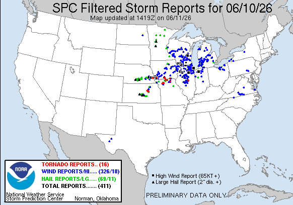
Issued June 11 at 7:34AM CDT until June 11 at 3:00PM CDT by NWS Des Moines IA
National Weather Service forecasters issued Tornado Watch 311 at 7:34 a.m. CDT on June 11 for parts of central and southeast Iowa, with the alert set to run until 3 p.m. CDT. For facility leaders watching operations in Jasper, Poweshiek, Appanoose, Lucas, Mahaska, Marion, Monroe, Wayne, Davis, and Wapello counties, this is a direct call to review a tornado shelter plan before storms move through.
Source: NOAA Storm Prediction Center
The watch replaces part of Severe Thunderstorm Watch 310 and includes cities such as Albia, Allerton, Bloomfield, Centerville, Chariton, Corydon, Grinnell, Humeston, Knoxville, Newton, Oskaloosa, Ottumwa, Pella, and Seymour. The National Weather Service said the primary threats include a few tornadoes, a couple of intense tornadoes, widespread damaging winds, and hail up to 2 inches in diameter.
For operations teams in these counties, the timing matters. A tornado watch means conditions are favorable for tornado development. It does not mean a tornado is on the ground, but it does mean readiness should move from planning to execution. In this part of Iowa, storms can organize quickly along warm, unstable air masses and advancing boundaries. June is a peak month for severe weather across the state.
The Storm Prediction Center has long noted that Iowa sits in a corridor where severe storms can produce both tornadoes and damaging straight-line winds. That mix can disrupt production lines, school schedules, utility service, and transportation. It can also force rapid movement of staff and visitors into protected areas. A tornado shelter plan should account for that speed.
The watch remains in effect through 3 p.m. CDT, which places the most active period squarely in the workday. Mean storm motion is east at 50 mph, so storms may cross multiple counties in a short window. That can compress decision time for plant managers in Newton, Oskaloosa, Ottumwa, and Pella.
The probability table from the National Weather Service points to a serious event. It shows a 50% chance of two or more tornadoes and a 30% chance of one or more strong EF2 to EF5 tornadoes. It also shows a 90% chance of 10 or more severe wind events. Those numbers are not routine. They support a high-alert posture for any site with large workforces, open yards, or critical equipment.
Damaging wind is often the broader operational threat in events like this. Roof damage, broken glazing, downed power lines, and debris impacts can halt work even when a tornado does not strike the property directly. In Jasper County and Mahaska County, that can mean production delays and access issues. In Wapello County and Davis County, it can mean temporary shutdowns and shelter-in-place decisions.
For a facility manager, the question is not only whether a warning is issued. The question is whether staff can reach a protected area fast enough. A tornado shelter is part of that answer, especially when the watch covers a broad area and storms are moving east at 50 mph.
This event is anchored in a familiar Iowa severe weather pattern. Late spring and early summer often bring strong instability, moisture, and wind shear together over the Midwest. When those ingredients align, tornadoes can form quickly, and hail can become large enough to damage roofs, siding, and vehicles. The risk is especially relevant for industrial sites with loading docks, outdoor storage, and high-bay structures.
The National Weather Service alert also highlights isolated very large hail and wind gusts to 80 mph. That combination can create immediate safety concerns for workers outdoors and for anyone moving between buildings. It can also complicate emergency response if roads are blocked by debris or if power is interrupted. For sites in Marion, Monroe, and Wayne counties, that means the watch should be treated as an operational issue, not just a weather update.
In events like the June 11 Tornado Watch, the best-performing facilities are usually the ones that already know where people will go. That includes shift workers, contractors, and visitors. It also includes staff who may not be familiar with the site. A commercial tornado shelter can reduce confusion when minutes matter and conditions are changing fast.
For broader planning, facility leaders can review service areas and align shelter planning with local risk. The goal is to match capacity, access, and placement to the actual footprint of the site. That is especially important in counties where multiple buildings, parking lots, or yard operations spread people across a large property.
This watch is a reminder that severe weather planning has to fit the site, not the calendar. A tornado shelter matters most when warning lead time is short and staff are dispersed. That is common in manufacturing plants, distribution centers, and industrial campuses across central and southeast Iowa.
Facility managers can use our Storm Planner to evaluate shelter placement before the next severe weather outbreak. The tool helps teams think through occupancy, access routes, and practical capacity before a watch turns into a warning. For a site in Jasper County or Wapello County, that preparation can shape how quickly people move to safety.
The National Weather Service issues watches to give communities time to prepare. That time is limited. It is also the window when a site can confirm who is on property, where they will report, and whether the shelter plan still works for current staffing levels. For industrial operators, that review should include contractors, maintenance crews, and visitors who may not know the drill.
In this event, the risk profile includes tornadoes, damaging winds, and large hail. A tornado shelter is one part of a broader severe weather program. It should be paired with alerting, accountability, and clear movement routes. In a watch that covers Albia, Ottumwa, Grinnell, and Knoxville, those details can determine how smoothly a facility responds.
Industrial and manufacturing sites in the watch area should use this alert to confirm shelter capacity before storms arrive. If your current setup is temporary or undersized, review commercial tornado shelters and rental shelters that can fit your workforce and site layout. You can also use the Storm Planner to test placement against your headcount and building footprint.
If you need to compare options, photo gallery examples can help you visualize different shelter configurations. For questions about timing, sizing, or deployment in Iowa, contact our team. The current Tornado Watch for Jasper, Poweshiek, Appanoose, Lucas, Mahaska, Marion, Monroe, Wayne, Davis, and Wapello counties is a clear reminder to verify shelter readiness before the afternoon threat window closes.